Tropical Storm Dorian strides forward to the Caribbean
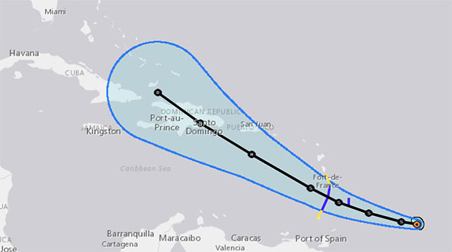
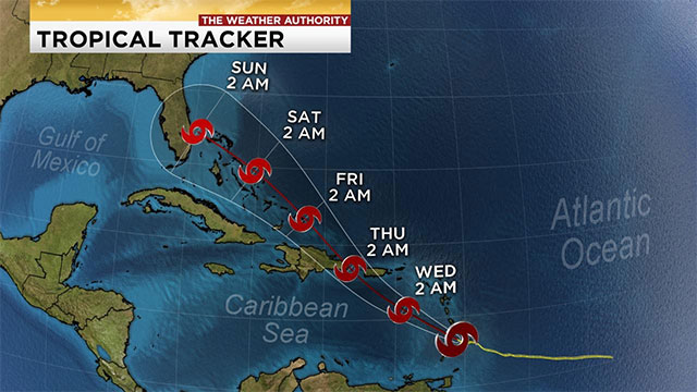
Dorian braces, eyes Puerto Rico and the Dominican Republic
Going from an average low-pressure center to a full-blown tropical cyclone in less than a day, Tropical Storm Dorian grew to be the 4th named storm of the Atlantic hurricane season on Saturday.
 As of Sunday evening, the storm had maximum winds of 85 km/h with higher gusts and was about 605 km east-southeast of Barbados. In spite of moving through a rather environment, atmosphere-wise, the storm is estimated to strengthen as it approaches the Lesser Antilles.
With warn sea surface temperatures expected to provide ample fuel for the system, current projections have Dorian at least briefly reaching hurricane strength Tuesday or Wednesday, as it continues on its track toward Puerto Rico and the Dominican Republic.
The 1st tropical storm warning associated with the storm has already been issued for regions of the Lesser Antilles. Dorian is supposed to be approaching the island of Barbados later on Monday. Tropical storm watches are even in effect for St. Lucia and St. Vincent and the Grenadines.
A Sneaky East Coast System?
For the moment, off the east coast of Florida, a disorganized region of low pressure and thunderstorms has even caught the eye of forecasters, and there is a non-zero chance it may, sooner or later, have a little form of impact on the United States northeast as well as Atlantic Canada.
The NHC said in a Sunday morning update, “Environment conditions appear conducive for gradual development, and a tropical or subtropical depression is likely to form within the next few days while the system moves slowly northeastward well offshore of the southeastern United States.”
Presently, the system is expected to track well offshore up the Eastern Seaboard, though some coastal spots still stand to see hefty rainfall totals. We are continuing to keep an eye on the possibility of a rainfall threat to Atlantic Canada as well.
Waters off the coast of the United States, particularly off the coast of Massachusetts, are much warmer than average, which means that it could enhance the storm development over the next few days. If the storm assumes tropical storm status, it will be given the name Erin.
The tropics have been relatively quiet for June, July and so far most of August. The climatological peak of the Atlantic hurricane season falls on about September 10, so the span from late August to early October tends to be the most active time of the year. The season runs from June 1 to November 30. Last year, Hurricane Florence and Hurricane Michael both took place in the second half of the season.

![10 Health & Safety Precautions During Rainy Season [Be Careful]](https://admin.goweatherforecast.com/images/1732692097.png)


0 Comments
Leave a Comment
Your email address will not be published. Required fields are marked *