A La Niña Winter Is Near. Here Are What You Should Know About It
A mild La Niña will likely affect temperatures, precipitation, and snowfall in the US.
La Niña is a natural climate pattern that causes lower-than-average water temperatures in the equatorial Pacific. The effects on weather are most noticeable in the Northern Hemisphere's winter months, with far less influence in the summer.
 A La Niña winter is coming
Last winter was the warmest on record for the Lower 48 due to La Niña's counterpart, El Niño, and global warming from fossil fuel emissions.
The prolonged mild weather prevented numerous significant snowfalls in the Northeast and Midwest, culminating in a winter snow drought measured in feet of missing snow.
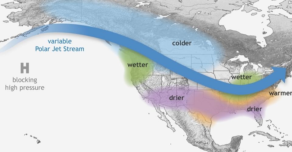
The Climate Prediction Center predicts a 60% chance of La Niña emerging by November. Once it comes, it is likely to stay for the whole winter and maybe into the early spring of the next year.
What could this winter look like?
While each La Niña winter is distinct, there are common tendencies in temperature and precipitation.
The whole northern tier of the United States is expected to be wetter than typical this winter, especially the Pacific Northwest, Midwest, and areas of the interior Northeast.
Wet weather will be critical in overcoming long-term dryness and drought in the Midwest.
Greater precipitation than usual does not imply more snow. Temperatures must be cold enough above and below the surface for snow to fall and stick on the ground.
A mild La Niña this year might modify the forecast. However, the center's most recent winter temperature estimates are not good news for snow fans in the Northeast.
Read next:
![10 Health & Safety Precautions During Rainy Season [Be Careful]](https://admin.goweatherforecast.com/images/1732692097.png)


0 Comments
Leave a Comment
Your email address will not be published. Required fields are marked *